



I'm aware that the role of advertisments is to encourage you to purchase the product, but I think a truly good ad is one that is memorable, inventive, becomes part of the vernacular, or a clever parody eg. the Evian baby one
I remember the best part of having to watch the football replays on a Saturday night was the series of SGIC ads - didn't make me want their insurance (the South Australian State Government Insurance Commission), they were just well-made witty clips.(AAMI are currently attempting to emulate them, but it just doesn't have the same flair).
My favourite was the Milk Bar one, but I couldn't find it, so this is the second best (love the car-wash attendant). This one leaves Mr Bean for dead.
It is so easy to say "Sorry!"
Monday, 25 March 2013
Saturday, 16 March 2013
Gobsmacked
It is not enough that Facebook, iTunes, and the rest keep changing layouts, hiding features, etc - telling us that we want it that we just don't know we do, now Google have decided to retire Google Reader its RSS reader!
Having had to change from Bloglines to Google Reader, I'm not impressed with the decision from the people who wish to be the sum of all printed knowledge. The 'RichSiteSummary Feed' harks back to my early blogging days with '23Things', monitoring the sites I follow for new stories.
 |
| Copied from the New York Times |
Thursday, 14 March 2013
Literal literates

What should have been a winning word score - was disallowed. Seems the people at Words With Friends aren't big library users (also checked with Scrabble word finder and it didn't include it either - Philistines!)it may be disallowed due to it being a 'proper noun' but that just takes all the fun out of the situation.
Words With Friends is like an app version of Scrabble (selecting lettered tiles of differing values to create words horizontally or vertically) allowing you to play remotely with your. ..friends!
Sunday, 3 March 2013
Battle Victor

The first time I watched "Time Team" on tv, I thought I recognised the style used in the pencil sketches - looks just like Victor Ambrus, later I checked the credits - yep Victor G. Ambrus.
I fell in love with Victor's work when reading childrens books (many of them Australian) - all the Nan Chauncy's, Elyne Mitchell's "Silver Brumby" books, Ronald Welch, K.M. Peyton's "Flambards" series, Rosemary Sutcliff ... even his picture book version of "Dracula".


 |
| A few simple lines create a sketch |
With a concise text explaining the background of each battle scene, "Battlefield panorama" is an art book.
Beginning with the siege of Troy, there's Caesar's invasion of Britain, the Viking raid of Lindisfarne, the Battle of Hastings, the bowmen at Agincourt, the Battle of Sedgemoor, the storming of the Bastille, Trafalgar and Waterloo, The Franco-Prussian War, the British Expeditionary Force in the First World War, the Normandy Landings, and the 1956 Hungarian Uprising (this takes on particular power and resonance when you know that Victor was actually there).
 |
| The Siege of Athlone in 1691 |
 |
| Classic Victor - the Iceni Uprising |
 |
| The Battle of Trafalgar |
He has been part of the Time Team as its reconstruction artist for many years. Tony Robinson (the presenter and world's best audio book narrator) describes him as 'an archaeological alchemist - he can transform a few stones and bits of pot into a vivid world of living, breathing people'.

Thursday, 21 February 2013
Fire by night
 |
| At Brimpaen, 7:30pm on 20th |
The fire takes on a different aspect at night -
 |
| From Gary Smith of Casterton |
It has now grown to over 32,500 hectares.
 |
| Brimpaen on 21st, Lynton says this thunderhead had its own lightning show |
The Henty Highway remains closed between the Brimpaen-Laharum Road and Mooralla. Diversions are in place at Horsham and Cavendish.
 |
| Between Brimpaen & Cherrypool looking southeast, on 21st |

Compare this CFA map to the one in the previous post. This image was created at 8am today.
 |
| From Reeds Lookout overlooking the Victoria Valley to the fire on the Victoria Range |
Tuesday, 19 February 2013
Ongoing fires
 |
| North of the Western Highway looking south to the Grampians, 10pm on 18th |
This morning DSE & Parks Victoria advised that multiple fires (14) occurred due to lightning strikes in the Grampians National Park area. All fires are small and not posing any threats to park visitors or adjoining landholders. The fires are being controlled by DSE and Parks Victoria crews supported by water bombing aircraft. The fires were started by lightning, and are located in the Mt William, Victoria Valley, and Mt Abrupt areas. More lightning activity is expected this afternoon and overnight.
 |
| In the Southern Grampians, on Saturday 16th |
 |
| The smoke trapped in a inversion layer on 16th, south of Glenisla |
 |
| Long exposure looking back to the Grampians, 11:15pm on 17th |


A map representation from the CFA Country Fire Authority of the Grampians fire (as at 19th).
The Blue symbol = Controlled, Yellow + Contained, and Red = Going.
The fire is now breaking out of the range and national park and heading west to threaten private land and the Henty Highway (the red line).
The Grampians fires are not the largest bushfire in Victoria at present. From the CFA's site on 10th, the map below gives you an idea of the size of the Aberfeldy fire (currently over 82,000 hectares) here's how it would look if it was across Melbourne.

 |
| Images from Crusty's mobile phone |
 |
| Infrared camera image for identifying fire hotspots (from CFA) |
On the 8th February, this fire at Mt Arapiles didn't even seem to rate a mention in the news. CFA crews stopped this fire on Friday, less than 100 metres from the forest flanking Mt Arapiles.
 |
| Aerial shot from the CFA |
Thursday, 14 February 2013
Nature's most electrifying
There has been some dramatic weather around during the last 24 hours, and its progress is best demonstrated by photographer Lynton Brown who as usual was out taking photos of sunrises, sunsets and clouds.
 This first in the sequence was taken just before 4:30pm looking west towards the approaching storms. At that stage he was checking the weather radar with storms near the border, Kaniva and Goroke areas.
 Snapped on his way to the Grampians, to capture the action, the storm front is approaching.
Looks like the Laharum shot is now Lynton's Facebook Cover Photo - check out more of his work at his facebook site Lynton Brown Photography or his website
Inevitably all this dramatic climatic action caused a number of bushfires from lightning strikes, fortunately the accompanying rain dampened some.
This morning DSE & Parks Victoria advised that multiple fires (14) occurred due to lightning strikes in the Grampians National Park area. All fires are small and not posing any threats to park visitors or adjoining landholders. The fires are being controlled by DSE and Parks Victoria crews supported by water bombing aircraft. The fires were started by lightning, and are located in the Mt William, Victoria Valley, and Mt Abrupt areas. More lightning activity is expected this afternoon and overnight.
On the opposite side of Horsham, the Country Fire Authority advises that there is fire
activity in the Little Desert National Park, where multiple lightning strikes overnight
caused multiple fires in the area. These fires are being controlled and emergency
crews are monitoring the area. Smoke may be visible from the nearby communities
of Goroke, Gymbowen, Minimay, Miram South, Kaniva, Miram, and Ozenkadnook.
Then to the west are the Kadnook fires (affecting Kadnook, Harrow, Edenhope, Powers Creek, and Dergholm) also started by lightning these were the earliest strikes and being controlled.
To all the firefighters and residents out there - play it safe.

 |
| An hour later - 5:30 near Drung |

 |
| Taken at the Laharum Football Ground, the Grampians in the background |
 |
| Near Mount Zero |
This morning DSE & Parks Victoria advised that multiple fires (14) occurred due to lightning strikes in the Grampians National Park area. All fires are small and not posing any threats to park visitors or adjoining landholders. The fires are being controlled by DSE and Parks Victoria crews supported by water bombing aircraft. The fires were started by lightning, and are located in the Mt William, Victoria Valley, and Mt Abrupt areas. More lightning activity is expected this afternoon and overnight.
Then to the west are the Kadnook fires (affecting Kadnook, Harrow, Edenhope, Powers Creek, and Dergholm) also started by lightning these were the earliest strikes and being controlled.
To all the firefighters and residents out there - play it safe.
Wednesday, 13 February 2013
Boort to its knees

Driving through Boort yesterday, my passenger (on lookout duty) drew my attention to the Boort railway station building.
The railway station at Boort is a closed and unused railway
station located on the Robinvale line. The line branches from the Mildura line
at Dunolly.
The line to Boort opened in 1883. Passenger services to the station
ended in June 1978.
Today the rail line today is a grain only service (there is
a GEB siding nearby), and containerised freight to Boort is operated by Wimmera Container
Lines.
 |
| A broken window provides views of a partly trashed interior |
 |
| A quaint little picket fence shaded by an old elm |
 |
| The track switching gear beside the station building |
Friday, 8 February 2013
Yet more light
WebUrbanist have come up with more lighthouses. This post is titled Coast Stories: 9 More Abandoned Lighthouses.

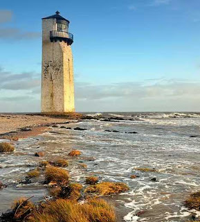
Southerness Lighthouse, located on the southwestern coast of Scotland near Dumfries, is the second-oldest lighthouse in Scotland – built in 1749, its beacon was first lit in 1800. The square lighthouse is surrounded by the sea at high tide. The lighthouse was raised in 1795 and again in 1844 to its current height of 17 meters (56 ft), the latter modification giving the tower its distinctive squared-off style. The lighthouse’s lamp was extinguished between 1867 and 1894 due to financial difficulties and snuffed for good in 1936.
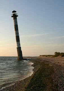
When coastal
erosion is accelerated by rising sea levels, shore-level lighthouses like the
leaning Kiipsaare Lighthouse on Estonia’s Saaremaa island lose out. Built in
1933 at a seemingly safe 25 meters from shore, the lighthouse’s base is now
completely awash during high tide. The good news is now that the waves can do
damage to all sides of the lighthouse’s base, the tower’s formerly pronounced seaward
lean has been reversed. The lighthouse was made inactive in 1992. For philatelic
fans a Kiipsaare lighthouse stamp was issued last week.
There are more lighthouses mentioned at the WebUrbanist post

 |
| Whiteford Point Lighthouse |

Whiteford
Point Lighthouse located just off the coast of Gower Peninsula at Whiteford
Point, south Wales, was a triumph of engineering in its heyday. Activated in
1866 and turned off for good in 1921, the lighthouse’s cast-iron walls were
once covered in protective black bitumen. 105 tapered cast-iron plates, each
one 32mm (1.28 inches) thick, form the lighthouse’s outer walls. The plates
were fastened to one another with cast-iron bolts weighing 2 pounds each. It
sits on a pitched stone apron just above the low-water mark in the Loughour
Estuary. Sixty years after its decommissioning and in response to pleas from local
fishermen, the Whiteford Point Lighthouse was relit using an automatic
solar-powered beacon but when that failed a few years later, the lighthouse was
dimmed permanently.

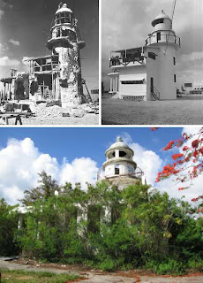
Following
World War I, the Japanese Empire seized the Northern Mariana Islands from
Germany and developed a substantial amount of infrastructure. The Garapan Lighthouse
on the island of Saipan sits on the highest point of Navy Hill, overlooking the
lagoon. The concrete structure stands about 50’ high and rises above a single-storey
gatekeeper’s quarters. Built in 1934, the lighthouse was extensively damaged
during the American invasion of Saipan in the summer of 1944. Following the
three-week battle, the 117th Seabees were sent in to repair the lighthouse. In
the early 1990s an attempt was made to repurpose the now-abandoned lighthouse
as a restaurant but by 1995 the venture was deemed unsuccessful and the
structure was once again abandoned to the vagaries of wind, weather and
vandalism.

Southerness Lighthouse, located on the southwestern coast of Scotland near Dumfries, is the second-oldest lighthouse in Scotland – built in 1749, its beacon was first lit in 1800. The square lighthouse is surrounded by the sea at high tide. The lighthouse was raised in 1795 and again in 1844 to its current height of 17 meters (56 ft), the latter modification giving the tower its distinctive squared-off style. The lighthouse’s lamp was extinguished between 1867 and 1894 due to financial difficulties and snuffed for good in 1936.

There are more lighthouses mentioned at the WebUrbanist post

Subscribe to:
Posts (Atom)
