WebUrbanist have come up with more lighthouses.
This post is titled Coast Stories: 9 More Abandoned Lighthouses.
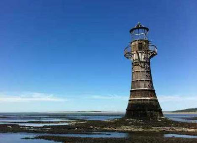 |
| Whiteford Point Lighthouse |
Whiteford
Point Lighthouse located just off the coast of Gower Peninsula at Whiteford
Point, south Wales, was a triumph of engineering in its heyday. Activated in
1866 and turned off for good in 1921, the lighthouse’s cast-iron walls were
once covered in protective black bitumen. 105 tapered cast-iron plates, each
one 32mm (1.28 inches) thick, form the lighthouse’s outer walls. The plates
were fastened to one another with cast-iron bolts weighing 2 pounds each. It
sits on a pitched stone apron just above the low-water mark in the Loughour
Estuary. Sixty years after its decommissioning and in response to pleas from local
fishermen, the Whiteford Point Lighthouse was relit using an automatic
solar-powered beacon but when that failed a few years later, the lighthouse was
dimmed permanently.
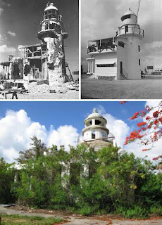
Following
World War I, the Japanese Empire seized the Northern Mariana Islands from
Germany and developed a substantial amount of infrastructure. The Garapan Lighthouse
on the island of Saipan sits on the highest point of Navy Hill, overlooking the
lagoon. The concrete structure stands about 50’ high and rises above a single-storey
gatekeeper’s quarters. Built in 1934, the lighthouse was extensively damaged
during the American invasion of Saipan in the summer of 1944. Following the
three-week battle, the 117th Seabees were sent in to repair the lighthouse. In
the early 1990s an attempt was made to repurpose the now-abandoned lighthouse
as a restaurant but by 1995 the venture was deemed unsuccessful and the
structure was once again abandoned to the vagaries of wind, weather and
vandalism.
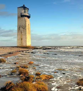
Southerness
Lighthouse, located on the southwestern coast of Scotland near Dumfries, is the
second-oldest lighthouse in Scotland – built in 1749, its beacon was first lit
in 1800. The square lighthouse is surrounded by the sea at high tide. The
lighthouse was raised in 1795 and again in 1844 to its current height of 17
meters (56 ft), the latter modification giving the tower its distinctive
squared-off style. The lighthouse’s lamp was extinguished between 1867 and 1894
due to financial difficulties and snuffed for good in 1936.
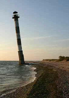
When coastal
erosion is accelerated by rising sea levels, shore-level lighthouses like the
leaning Kiipsaare Lighthouse on Estonia’s Saaremaa island lose out. Built in
1933 at a seemingly safe 25 meters from shore, the lighthouse’s base is now
completely awash during high tide. The good news is now that the waves can do
damage to all sides of the lighthouse’s base, the tower’s formerly pronounced seaward
lean has been reversed. The lighthouse was made inactive in 1992. For philatelic
fans a Kiipsaare lighthouse stamp was issued last week.